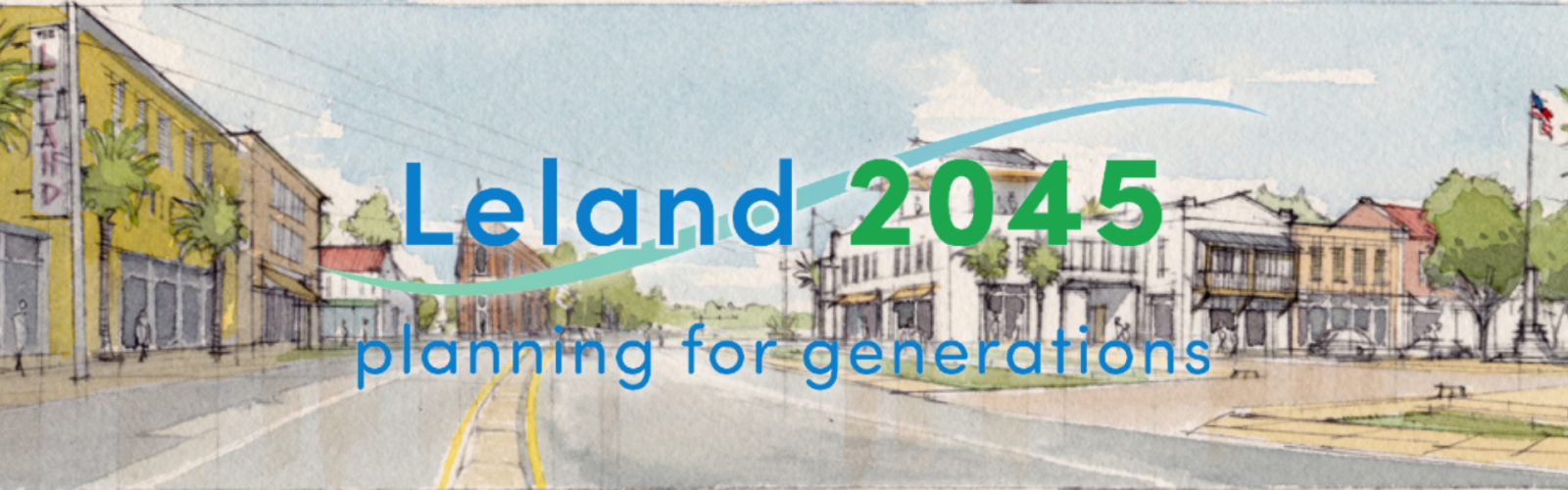
On November 18, 2021, Leland Town Council adopted the Leland 2045 comprehensive land use plan, setting the policy direction for land use, development, and open space preservation as Leland grows, increases in population, and changes in demographics. Leland 2045 is a planning document that outlines goals, policies, and implementation strategies that were developed through a robust public engagement process. The purpose of Leland 2045 is to enable Leland officials and citizens to anticipate and constructively respond to growth and change, and to encourage the development of safe and healthy built and natural environments that create opportunities for all.
This chapter provides an overview of the plan, how to use this document, a summary of previous plans, and the community process that informed this plan, as well as the vision statement, goals, and plan themes that shape the document.
In this chapter, the Leland 2045 vision, opportunity, principles, and strategies have been organized into six themes derived from engagement with the community.
The Action Playbook chapter covers implementation, priority investment, and organizes specific actions into a matrix action plan by theme establishing timing, level of investment, and assigning responsibility.
View the Leland 2045 Action Playbook — Updated Jan. 2025
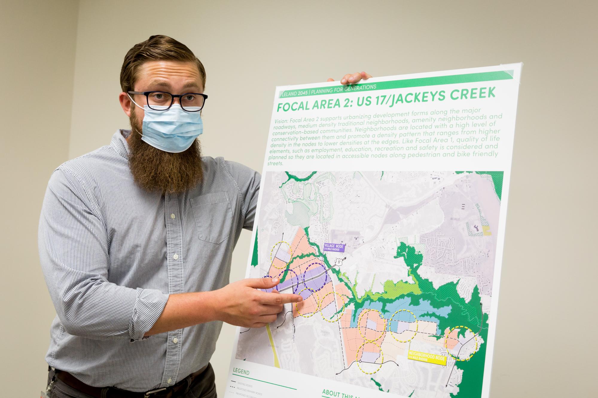
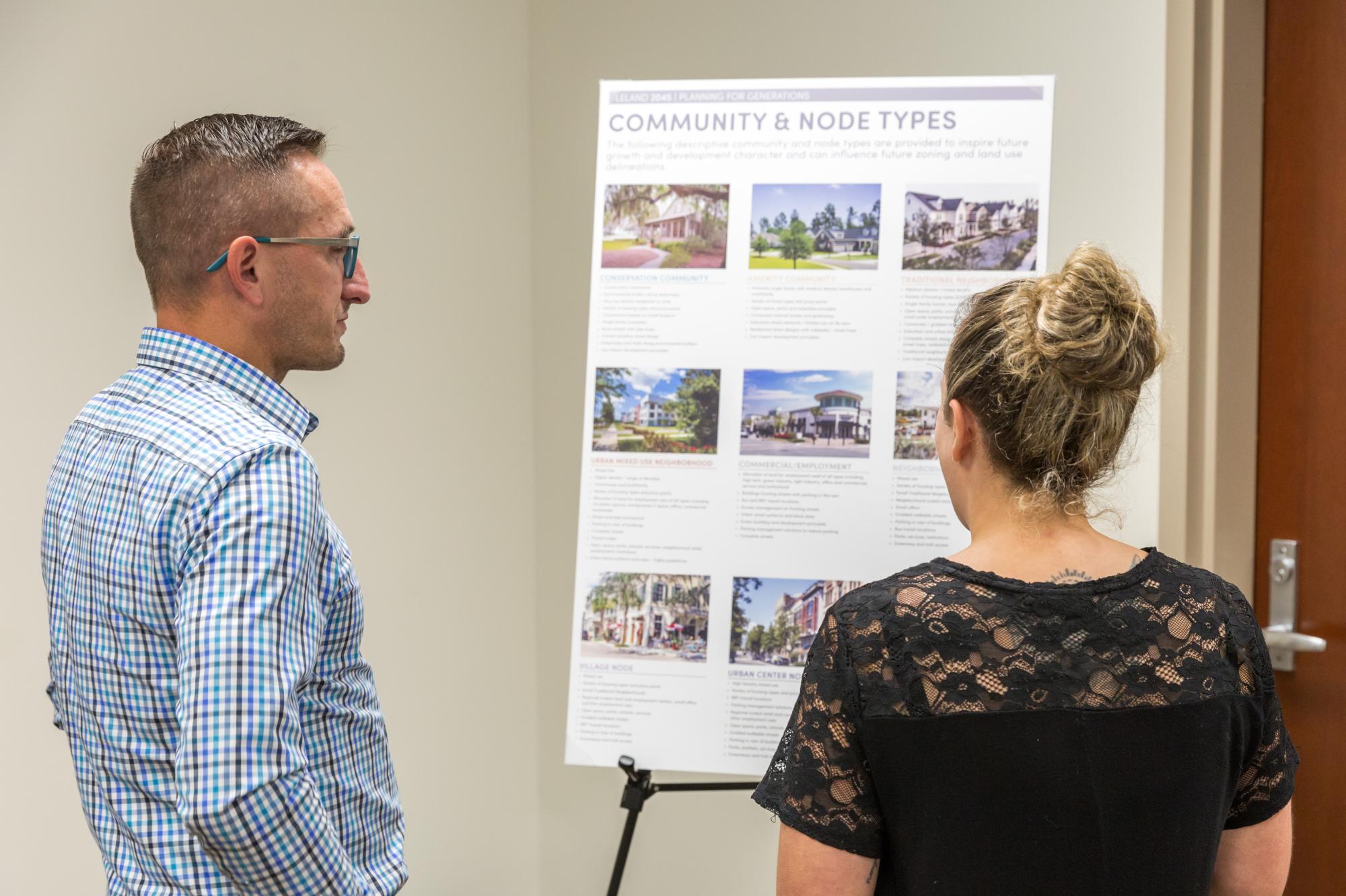
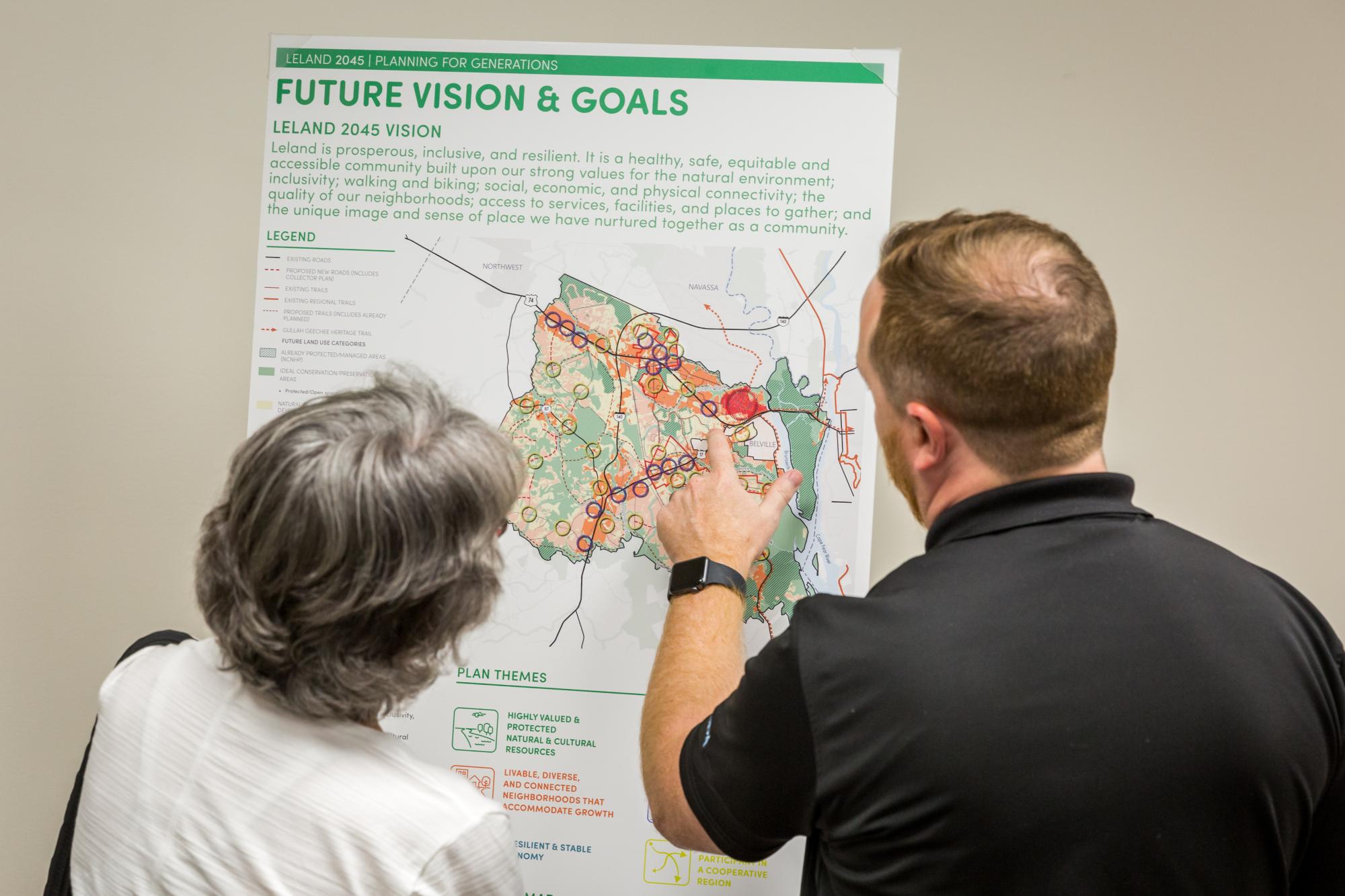
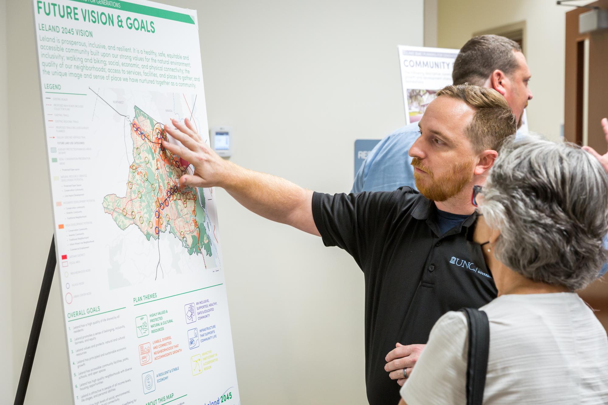
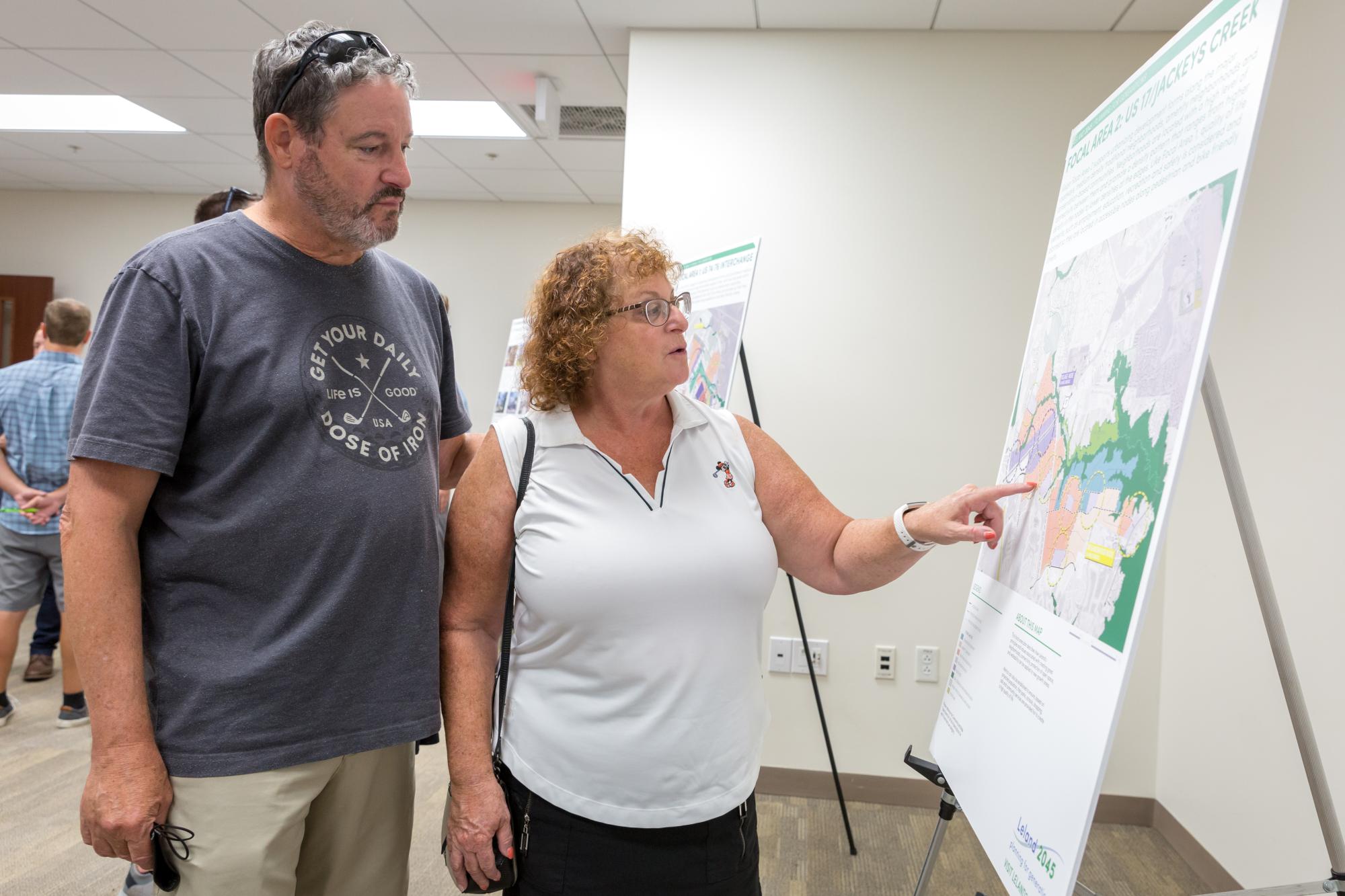
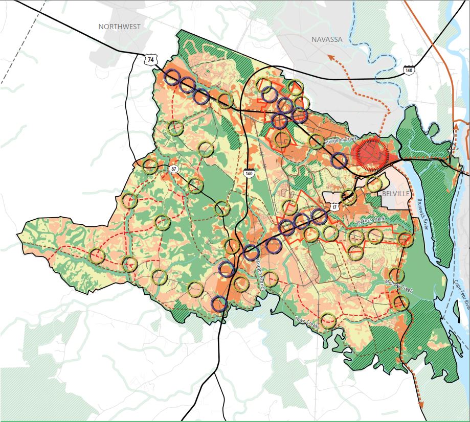
This chapter focuses on the key principles guiding urban and community frameworks, the Future Land Use Map (FLUM), and focal area studies. These frameworks will guide the Town on establishing policy direction and principles for planning the built environment with consideration for locating future parks, schools, community services, and street and trail improvements.
The Existing Conditions chapter captures a "snapshot" in time in the Town of Leland and the planning study area and takes a look at emerging issues and opportunities. This report is organized by the elements required by CAMA and reviews population growth, key demographics, housing stock, employment and job information, natural systems and environmental conditions, and information about current land use, community facilities, and the built environment.
The Addendum certifies Leland 2045 as a Coastal Area Management Act (CAMA) land use plan. While CAMA certification is not required, it plays a vital role in guiding sustainable growth and protecting our natural resources. Certification was achieved through the creation of an addendum that provides updated socioeconomic data and incorporates policies related to development in areas of environmental concern.
Quarterly Updates
Between now and 2045, we are committed to providing quarterly updates on the progress made on this plan to show the initiatives taken towards building a better and brighter Leland.
Highly Valued and Protected Natural and Cultural Resources
- Town Council approved the voluntary annexation and initial zoning of approximately 150 acres along the Highway 74/76 corridor. Portions of the property were designated as conservation district.
A Resilient and Stable Economy
- Town Council approved a text amendment to provide development standards and establish a public input process for data centers looking to locate within the Town.
Infrastructure that Supports Community Life
- The North Carolina Emergency Management Disaster Relief and Mitigation Fund, awarded the Town $400,000 in grant funding, bringing total external funding for the Low Country Boulevard Culvert Improvement Project to approximately $1.4 million.
An Inclusive, Supported, Healthy, Safe, and Educated Community
- A consultant has been selected by Town staff to create updated Parks, Recreation, and Open Space Plan.
An Active Participant in a Cooperative Region
- The Planning and Inspections Department met with local municipalities and organizations to discuss trail connectivity across the region and expansion of the Gullah Geechee Heritage Trail.
View the full quarterly update.
A Resilient and Stable Economy
- Rezoned approximately 1.45 acres near Hawthorne Waterside Apartments at the intersection of Highway 17 and Hubert Way from multi-family district to general commercial district to better integrate housing with services and amenities, resulting in a more walkable community.
An Inclusive, Supported, Healthy, Safe, and Educated Community
- The Leland Police Department earned full accreditation from the North Carolina Law Enforcement Accreditation Program.
- The Leland Police Department completed its second North Carolina League of Municipalities Law Enforcement Risk Review process.
Infrastructure that Supports Community Life
- Installed four rectangular rapid flashing beacons along Town Hall Drive, funded primarily by the $15,000 AARP Community Challenge Demonstration Grant.
- Initiated work on the Ocean Gate Plaza intersection improvements.
- Completed the 2024-2025 road resurfacing project.
- Began phase two of the Jackeys Creek streamflow rehabilitation project.
Highly Valued and Protected Natural and Cultural Resources
- Rezoned approximately 4 acres adjacent to Mill Creek and Village Road to conservation district.
Livable, Diverse, and Connected Neighborhoods that Accommodate Growth
- Rezoned approximately 515 acres along U.S. Highway 17 between the Westgate shopping area and Brunswick Forest, and along N.C. 133 (River Road) north of the Westport neighborhood to FlexCode zoning.
Infrastructure that Supports Community Life
- Installed bike lanes on Grandiflora Drive in Magnolia Greens as part of the 2024-2025 roadway resurfacing project.
- Began the design phase of the Leland unpaved roads improvements project.
- Awarded $443,108 from the North Carolina Parks and Recreation Trust Fund to build a public boat dock and boardwalk at the future Sturgeon Creek Park.
- Began the construction phase of the Ocean Gate Plaza intersection improvements project.
Quarterly updates to Leland 2045 seek to show how all Town departments are incorporating the plan's current and long-range goals. These updates will be shared each quarter with Town Council and on the Town's website and social media platforms.
View the full quarterly update.
Highly Valued and Protected Natural and Cultural Resources
- Cleared approximately 8,600 linear feet of vegetative debris from Jackeys Creek through the North Carolina Department of Agriculture’s Streamflow Rehabilitation Assistance Program.
Inclusive, Supported, Healthy, Safe, and Educated Community
- Hosted a dementia awareness workshop for staff in partnership with the Cape Fear Area Agency on Aging and Brunswick Senior Resources.
- Hosted the fifth annual Hurricane Expo.
Infrastructure that Supports Community Life
- Town Council adopted the Integrated Mobility Plan.
View the full quarterly update.
A Resilient and Stable Economy
- Visit Leland hosted an open house and launch an online survey to gather community input for the Tourism Development Strategic Plan.
An Inclusive, Supported, Healthy, Safe, and Educated Community
- Partnered with the Caregiver Academy and Brunswick Senior Resources to host a movie screening and share resources for those supporting loved ones with dementia.
Infrastructure that Supports Community Life
- Town Council adopted the Safe Streets and Roads for All Comprehensive Safety Action Plan.
- Community partners, AARP NC Coastal Region and We Live Here Leland, shared key findings from the Lend a Hand in Leland Walk Audit with Town Council.
View the full quarterly update.
Highly Valued and Protected Natural and Cultural Resources
- The Town applied to the U.S. Forestry Service's Community Forest Grant program with support from the Coastal Land Trust to acquire land that will be zoned conservation.
A Resilient and Stable Economy
- The Leland Tourism Development Authority began collaborating with the National Travel Center to develop a Tourism Development Strategic Plan.
An Inclusive, Supported, Healthy, Safe, and Educated Community
- Awarded a $1,200 grant from the Brunswick Arts Council to support Art Around Town programming.
Infrastructure that Supports Community Life
- Preliminary design plans for the U.S. Highway 17 Pedestrian Crossing project are under North Carolina Department of Transportation technical review.
- Completed the Mallory Creek Drive Sidewalk Extension project.
- Sturgeon Creek Park public boat ramp design is under Town review through partnership with North Carolina Wildlife Rescue Resource Commission.
- Approved final design plans to resurface several streets within Town limits.
View the full quarterly update.
Highly Valued and Protected Natural and Cultural Resources
- Awarded a $344,000 grant from the Streamflow Rehabilitation Assistance Program to fund the cleanup and removal of vegetative debris in Jackeys Creek.
- Completed and closed out the Leland Resilient Routes Project.
Livable, Diverse, and Connected Neighborhoods that Accommodate Growth
- Started design and survey work on the U.S. Highway 17 Pedestrian Crossing project.
- Town Council adopted the Town of Leland 2030 Strategic Plan.
A Resilient and Stable Economy
- Published its first Revenue Manual.
- Received the Distinguished Budget Presentation Award for the Fiscal Year 2024-2025 Budget.
- Received the Certificate of Achievement for Excellence in Financial Reporting for the Annual Comprehensive Financial Report for Fiscal Year 2022-2023.
- The Leland Tourism Development Authority awarded $70,000 in grants to assist with the marketing and promotion for three tourism-related events in Leland.
An Inclusive, Supported, Healthy, Safe, and Educated Community
- The Town’s Public Safety departments adopted their 2025-2029 Strategic Plans.
- Leland Fire/Rescue provided fire safety education to several area schools during Fire Prevention Week.
- The Leland Police Department hosted Coffee with a Cop and National Night Out.
- Awarded $6,207.50 from the U.S. Department of Justice Patrick Leahy Bulletproof Vest Partnership to reimburse the Town for 50% of bulletproof vests for officers.
- Awarded $25,000 from Duke Energy’s Local Impact Grant to enhance the current land mobile radio system, ensuring robust and reliable communication during natural disasters.
- Held the second Lend a Hand in Leland community-wide day of service.
- Held a Fair Housing Workshop to offer residents information on first-time homebuying, the Community Development Block Grant housing repair assistance program, and foreclosure prevention.
Infrastructure that Supports Community Life
- Paved Perry Avenue and the new extension.
- Started construction on the Mallory Creek Drive Sidewalk Extension project, which consists of the removal of a mid-block crossing and extension of the sidewalk to Bimini Drive at the controlled intersection. The sidewalk and ADA improvements will make it safer for pedestrians to cross Mallory Creek Drive.
An Active Participant in a Cooperative Region
- Leland Police hosted area law enforcement personnel for the last of three FBI-Law Enforcement Executive Development Association leadership classes.
View the full quarterly update.
Highly Valued and Protected Natural and Cultural Resources
- Town Council adopted the Green Network Master Plan Framework Guide.
- Completed renovations to the Cypress Cove Park boardwalk.
Livable, Diverse, and Connected Neighborhoods that Accommodate Growth
- Published the final report for the Leland Resilient Routes Project.
- Awarded two bicycle racks and an ADA-compliant self-service repair public work stand by the NC Division of Public Health, aiming to promote physical activity as a mode of transportation.
A Resilient and Stable Economy
- The Town was assigned an Aa1 initial user rating and an Aa2 rating for its limited obligation bonds, and the Local Government Commission approved Leland’s application to issue up to $13.5 million in bonds for the Leland Town Hall expansion project.
- Town Council approved a $50 million budget for fiscal year 2024-2025.
An Inclusive, Supported, Healthy, Safe, and Educated Community
- Created the Town of Leland Hurricane Guide to assist residents in preparing for hurricane season.
- Completed the Age-Friendly Community Strategic Plan in collaboration with AARP.
- Hosted the annual Hurricane Expo to prepare residents for hurricane season.
- The Police Department completed incident command training to enable officers to establish and fulfill the role of incident commander.
Infrastructure that Supports Community Life
- The Safe Streets 4 All public outreach phase began.
- Started discussing timelines and project plans for the Integrated Mobility Plan.
- Completed the Mallory Creek Drive drainage improvements from Pine Cone Drive to Blue Spruce Way.
- Awarded a $1 million Disaster Relief and Mitigation Fund grant from North Carolina Emergency Management to assist with the Old Fayetteville Road Culvert Replacement project.
An Active Participant in a Cooperative Region
- The Town and H2GO have jointly applied to relocate the South Navassa Sewer Pump Station. FEMA is currently reviewing the application for environmental and historic preservation consideration.
- Leland Fire/Rescue held truck operations and hose line training with firefighters from Calabash, Horry County, Sunset Beach, and Ocean Isle Beach.
Quarterly updates to Leland 2045 seek to show how departments Town-wide are incorporating the plan's current and long-range goals. These updates will be shared each quarter with Town Council and on the Town's website and social media platforms.
View the full quarterly update and newsletter.
Highly Valued and Protected Natural and Cultural Resources
- Completed the Green Growth Network Framework Guide in collaboration with the North Carolina Wildlife Resources Commission to enhance the Town’s environmental character.
- Participated in the NCDOT Spring Litter Sweep, collecting 470 pounds of trash along S. Navassa Road and U.S. Highway 17.
- Created the Town’s CAMA Map, which delineates areas within the planning area that are subject to state development regulations, in collaboration with the Division of Coastal Management.
Livable, Diverse, and Connected Neighborhoods that Accommodate Growth
- Amended the Code of Ordinances to create minimum lot sizes for duplexes, triplexes, and quadraplexes that help support the density limits and character of the zoning district.
- Progress continued at Founders Park as crews prepared for the installation of the Perry Avenue extension, poured footers and slabs for the amphitheater and pavilion, installed stormwater infrastructure, and began installing the splash pad.
A Resilient and Stable Economy
- Hosted the inaugural Leland Life Science and Medical Technology Summit.
- Amended the Code of Ordinances to remove residential uses within commercial districts.
- Held an emergency management exercise for Town staff focused on the continuity of government operations during a Town-wide emergency.
An Inclusive, Supported, Healthy, Safe, and Educated Community
- Held two public Open House events to get feedback on the draft of the Age-friendly Strategic Plan.
- The Leland Fire District earned a Class 2 Fire Rating, putting Leland Fire/Rescue among the top 8% of fire departments in the state.
- Awarded $1,200 to support the Art Around Town program.
- Awarded $4,780 from the North Carolina League of Municipalities (NCLM) Insurance Pool Safety Grant to purchase body-worn cameras.
Infrastructure that Supports Community Life
- The Safe Streets 4 All Focus Group met to draft goals and priorities for the project.
- Awarded $5,000 from the NCLM Insurance Pool Safety Grant for Property & Liability to reduce the potential for future property and liability insurance claims by installing a fence at the Municipal Operations Center and Fire Station 51.
- Selected an engineering firm to design the U.S. Highway 17 Pedestrian Crossing.
An Active Participant in a Cooperative Region
- The Police Department held two national law enforcement leadership training courses for Town staff and statewide police departments.
Quarterly updates to Leland 2045 seek to show how departments Town-wide are incorporating the plan's current and long-range goals. These updates will be shared each quarter with Town Council and on the Town's website and social media platforms.
Highly Valued and Protected Natural and Cultural Resources
- Partnered with H2GO on a grant application for FEMA's Building Resilient Infrastructure and Communities program to relocate an existing sewer pump station out of a flood hazard area adjacent to Sturgeon Creek.
Livable, Diverse, and Connected Neighborhoods that Accommodate Growth
- Construction commenced on Founders Park renovations.
- Amended the Code of Ordinances, improving street design and access requirements for subdivisions.
- The Town has been designated as a Class 7 Community by FEMA's Community Rating System program, allowing homeowners to save 15% off flood insurance premiums beginning in October 2024.
A Resilient and Stable Economy
- Assisted with the coordination of Harrington Square's first pop-up market.
- Three businesses held grand openings.
- Announced and started planning the inaugural Leland Life Science and Medical Technology Summit.
- Marketed the Leland Innovation Park to Cape Fear Commercial Real Estate Women and coordinated showings to spark development interest.
An Inclusive, Supported, Healthy, Safe, and Educated Community
- The Parks, Recreation, and Cultural Resources Department hosted its annual Holiday Art Market, supporting 38 artists with more than 1,100 attendees.
- Emergency Management hosted an incident command course for managers and supervisors.
- Awarded $29,720 from Firehouse Subs Safety Foundation for a hurst cutter, spreader, ram, and accessories for Leland Fire/Rescue.
Infrastructure that Supports Community Life
- Held a stakeholder meeting for the Leland Resilient Routes Project to identify critical route locations to be designed and modeled for enhanced resilience to coastal hazards.
- Began contract negotiations with consultants for the Safe Streets for All project.
- Advertised proposals for the Integrated Mobility Plan.
An Active Participant in a Cooperative Region
- Leland Fire/Rescue and the Wilmington Fire Department entered into an automatic aid agreement allowing each agency to dispatch to incidents in designated areas.
- The Police Department partnered with the Leland Public Library and several daycares for "Story Time Series with Chief Jeremy".
Quarterly updates to Leland 2045 seek to show how departments Town-wide are incorporating the plan's current and long-range goals. These updates will be shared each quarter with Town Council and on the Town's website and social media platforms.
Highly Valued and Protected Natural and Cultural Resources
- Awarded $1,000 from the North Carolina Recreation and Park Association towards the Town’s first Lend a Hand in Leland event.
- The NC Department of Environmental Quality is conducting a Brownfields Assessment for the future Sturgeon Creek Park.
Livable, Diverse, and Connected Neighborhoods that Accommodate Growth
- The Town's application to join FEMA's Community Rating System program as a Class 7 community has been accepted.
A Resilient and Stable Economy
- Emergency Management finalized a Debris Management Plan to assist with community recovery following a natural disaster.
- The Leland Tourism Development Authority awarded the Town $100,000 to go towards the construction of the amphitheater at Founders Park.
- The Communications and Human Resources Departments produced three recruitment videos that emphasize the Town’s culture to attract prospective employees.
- Staff presented the completed Feasibility Analysis and Economic Impact Study for the Jackeys Creek Development and proposed baseball stadium.
An Inclusive, Supported, Healthy, Safe, and Educated Community
- Awarded $2,500 from the Walmart Community Grant Program to purchase medical bags for Police vehicles.
- Awarded $3,300 from the Patrick Leahy Bulletproof Vest Partnership Program.
- The Police Department hosted National Night Out on Oct. 3 to interact with the community and promote neighborhood camaraderie.
- The Police Department hosted National Coffee with a Cop on Oct. 6 to meet and engage with the community.
- Leland Fire/Rescue conducted fire safety educational programs at area schools in October.
- Adopted regulations permitting wireless facilities towers in PUD districts which will expand and improve internet broadband services.
Infrastructure that Supports Community Life
- Opened the new Fire Station 51 along Highway 74/76.
- Closed on the purchase of approximately 190 acres of land for future public use.
An Active Participant in a Cooperative Region
- Planning and Economic and Community Development staff participated in an after work social with members of AARP and community group We Live Here Leland to discuss Town initiatives and hear citizen concerns.
- On Sept. 15, the Planning Department hosted the Town's first Parking Day, a global participatory event promoting safe and equitable access to public spaces and streets.
- Partnered with the WMPO, Town of Navassa, and the Town of Belville to host the fourth annual Brunswick Heritage Riverside Ride
Highly Valued and Protected Natural and Cultural Resources:
-
Initially zoned approximately 7.08 acres into the Conservation Zoning District.
-
The Town provided a letter of support for the WMPO's grant application for NCDOT's Paved Trails Feasibility Grant. The project pertains to the feasibility of constructing a 10'-12' multi-use path facility in the Gullah Geechee Heritage Corridor from Phoenix Park in Navassa to Brunswick Nature Park in unincorporated Brunswick County.
Livable, Diverse, and Connected Neighborhoods that Accommodate Growth:
-
Initially zoned approximately 13.26 acres into the Multi-Family Zoning District, which will be able to accommodate residential uses that can support the Town's influx of new residents.
A Resilient and Stable Economy:
-
From May to July, the Town annexed approximately 78.48 acres into the municipality for conservation, commercial, and residential land uses.
An Inclusive, Supported, Healthy, Safe, and Educated Community:
-
The Town was awarded $10,000 from FOCUS Broadband's Connect Grant program, which will be used on the upcoming Founders Park renovations.
-
Leland Fire/Rescue conducted live fire training on June 28 using a donated house. Multiple fire departments participated in this training.
-
Emergency Management held the Town's annual Hurricane Expo on June 10.
Infrastructure that Supports Community Life:
-
The Town applied to the NC Department of Environmental Quality for a Brownfields Assessment for the Future Sturgeon Creek Park.
An Active Participant in a Cooperative Region:
-
Police entered into an agreement with the State Bureau of Investigations to acquire criminal investigation training and equipment.
-
Police and Fire participated in a full-scale active shooter drill at Town Creek Middle School on June 15 with other law enforcement and fire agencies.
-
Fire is assisting the Brunswick County Fire Chiefs Association with conducting a Youth Fire Academy for high school students.
Highly Valued and Protected Natural and Cultural Resources:
-
Zoned approximately 83 acres into the Conservation District.
-
Amended the Flood Damage Prevention Ordinance to increase the freeboard of non-residential buildings located in a special flood hazard area.
Livable, Diverse, and Connected Neighborhoods that Accommodate Growth:
-
Opened the Olde Waterford Way Extension connecting the existing roundabout at Olde Regent Way to Palm Ridge Drive.
-
Opened a 2,900 foot, 12-hole disc golf course adjacent between Village Road and Sturgeon Creek.
A Resilient and Stable Economy:
-
Adopted the Town's first Economic Development Strategic Plan.
-
Annexed and established commercial zoning of approximately six acres.
An Inclusive, Supported, Healthy, Safe, and Educated Community:
-
Received six awards from the North Carolina Department of Labor (NCDOL) Safety Awards Program.
-
Emergency Management hosted a course on responding to active shooter incidents attended by over 100 emergency responders from across North Carolina.
Infrastructure that Supports Community Life:
-
Awarded $750,000 towards the engineering and design of the Gateway District Utility Resiliency project.
-
Awarded $80,000 through the Safe Streets and Roads for All grant program to develop the Town's first Comprehensive Safety Action Plan.
An Active Participant in a Cooperative Region:
-
The Fire Department has organized classes for all Brunswick County 911 Dispatchers to familiarize them with Leland and county-wide fire operations.
-
Police has renewed a Memorandum of Understanding with the North Carolina State Bureau of Investigation to assist each other with the investigation of Internet Crimes Against Children (ICAC).
Highly Valued and Protected Natural and Cultural Resources:
-
Zoned approximately 777 acres into the Conservation District.
-
The removal of vegetative debris has commenced on approximately 8,657 linear feet of streambank and encompass areas of Jackeys, Mill, and Sturgeon Creeks.
Livable, Diverse, and Connected Neighborhoods that Accommodate Growth:
-
Zoned approximately 68 acres into FlexCode zoning.
-
Unveiled a new 18-panel StoryWalk at Westgate Nature Park designed to encourage movement, reading, and creativity.
A Resilient and Stable Economy:
-
Adopted a Public Art Policy which enhances public spaces by way of the inclusion of public art.
-
Annexed approximately 2,142 acres into the Town.
An Inclusive, Supported, Healthy, Safe, and Educated Community:
-
Hosted a 2-day Incident Management Team course for Town staff who will assist with managing any large man-made or natural disaster or emergency.
-
Leland Fire/Rescue’s Community Risk Reduction Education Division conducted fire prevention and safety education at two local elementary schools which reached 1,420 children and 109 adults.
Infrastructure that Supports Community Life:
-
Completed the extension of Olde Waterford Way from Palm Ridge Drive to Olde Regent Way.
-
Finalize, the design of the drainage plan improvements of Mallory Creek Drive as a part of the North Carolina Resilient Coastal Communities Program.
An Active Participant in a Cooperative Region:
-
Approved a resolution supporting the WMPO's application to the Integrated Mobility Division Feasibility Study Grant Program to complete a feasibility study for a multi-use path along the Gullah Geechee Heritage Corridor.
Highly Valued and Protected Natural and Cultural Resources:
-
Completed a Tree Canopy Cover Assessment with the NC Forest Service, PlanIt Geo, and NC Urban Forest Council.
-
Awarded a Partners of Green Growth grant through NC Wildlife to complete a Green Network Plan Framework.
Livable, Diverse, and Connected Neighborhoods that Accommodate Growth:
-
Adopted the Americans with Disability Act Transition Plan which outlines a plan to become a more accessible community.
-
Annexed approximately 1,250 acres into the Town of Leland for conservation, residential, and commercial land uses.
A Resilient and Stable Economy:
- Executed an agreement with Creative Economic Development Consulting, LLC to prepare an economic development strategic plan and incentive policy.
An Inclusive, Supported, Healthy, Safe, and Educated Community:
-
Research proposed, in partnership with NC State University, was selected by NC SeaGrant for "Smart Zoning for Coastal Flood Adaptation and Resilience."
-
Joined the American Flood Coalition which is a nonpartisan coalition advocating for national solutions to flooding and sea level rise.
Infrastructure that Supports Community Life:
-
Appropriated $4.6 million to the Brunswick Village Boulevard Extension Project.
-
Awarded $666,623 by the Wilmington Urban Area Metropolitan Planning Organization for a portion of the estimated cost to design and construct a signalized pedestrian crossing on US Highway 17 at/near the intersection of Ploof Road and Old Waterford Way.
An Active Participant in a Cooperative Region:
-
Executed a mutual aid agreement between the Town of Leland and Carolina Beach Police Departments.
-
Executed an amendment to the memorandum of understanding between the Town of Leland Police Department and the Southeastern North Carolina Airborne Law Enforcement Unit to allow for access to drone resources.
Highly Valued and Protected Natural and Cultural Resources:
-
335 pounds of trash and recycling collected during Community Stream Cleanup.
-
Received $20,000 in Resilient Coastal Communities Program funding for engineering/design for a drainage plan.
-
Received $258,429 from the N.C. Department of Agriculture's Streamflow Rehabilitation Assistance Program to conduct vegetative debris removal in Leland streams.
-
Staff formed an internal Sustainability and Resiliency Committee.
Livable, Diverse, and Connected Neighborhoods that Accommodate Growth:
- Partnering with N.C. Forestry Service and N.C. Urban Forest Council to create a Tree Canopy Assessment.
A Resilient and Stable Economy:
-
Annexed approximately 190 acres into the Town, roughly 59 of which were zoned commercial.
-
The Interactive Gateway District Mapping Tool went live on the Town's website to guide redevelopment in the Gateway District.
An Inclusive, Supported, Healthy, Safe, and Educated Community:
-
Partnering with Cape Fear River Watch to conduct research about how much litter enters our stormwater system.
-
Launched the redesigned Town of Leland website to enhance user-friendliness and accessibility.
-
Fire Station 53 opened and is operational.
-
Fire Station 51 is under construction.
Infrastructure that Supports Community Life:
-
Received $950,000 in funding from the Transportation Infrastructure Resiliency Fund for the Leland Resilient Routes Project.
-
Awarded a dual-port electric vehicle charging station for Founders Park through Volkswagen Public Access Program.
An Active Participant in a Cooperative Region:
-
Entered into a Fire Automatic Aid Agreement with Winnabow Volunteer Fire Department.
-
Partnered with Cape Fear River Watch to place 20 "Do Not Dump-Drains to Creek" markers on stormwater drains.
-
Attended luncheon about planning in the region.
-
Participating in regional Community Health Needs Assessment.
Highly Valued and Protected Natural and Cultural Resources:
-
120 acres of land annexed for conservation.
-
1,380 pounds of trash and recycling cleaned during Employee Stream Cleanup.
-
Two miles of waterways cleaned through USDA Emergency Watershed Protection Project.
-
Open Space language to deed special environmental features within subdivisions as open space.
Livable, Diverse, and Connected Neighborhoods that Accommodate Growth:
-
ADA Transition Plan to convert all Town facilities to be ADA compliant.
-
Sweetbay Park acquired to establish a new 18-hole disc golf course.
-
Founders Park awarded grant for upgrades for a Veterans memorial, splash pad, amphitheater, restrooms, and playground renovations.
-
Pedestrian improvements including sidewalks along Town Hall Drive, Old Fayetteville Road, and Village Road and a multi-use path extension.
A Resilient and Stable Economy:
-
Public Safety department working to obtain the Storm Ready Community designation.
-
Leland Cultural Arts Center scholarship program.
-
Economic Development Committee completed an update of the 2019 Economic Development Strategic Plan.
-
Interactive mapping tool to guide redevelopment, economic growth, and public investment.
An Inclusive, Supported, Healthy, Safe, and Educated Community:
-
Substantially completed the construction of Fire Station 53, staffing, and apparatus upgrades.
-
Police Department completed the NCLM risk assessment affording the Town a reduction in insurance premium.
-
Joined AARP Network of Age-Friendly Communities to address multigenerational needs.
-
Enviroscape presentations by Cape Fear River Watch at Leland Middle School to teach watershed management.
Infrastructure that Supports Community Life:
-
Old Fayetteville Road Multi-Use Path won an NCDOT Mobi Award.
- Newly adopted open space regulations require major subdivisions to commit required riparian buffers, wetlands under federal or state jurisdiction, or special flood hazard areas towards passive open space requirements.
An Active Participant in a Cooperative Region:
-
Leland Police and Fire/Rescue joined the Cape Fear Regional Special Operations Team to contribute to the safety and security of the region.
-
Cape Fear River Watch LittaTraps Grant to collect data on pollutants entering the stormwater system.
-
Off Duty Management to manage off-duty Police Officer employment.
-
Participating in Cape Fear RISE to develop a portfolio of priority resilience projects that reduce risk.